Unmanned aircraft systems (UAS), or unmanned aerial vehicles (UAV) are widely used for military purposes, but civilian applications are a rapidly growing area for UAS due to their greater availability and the miniaturization of sensors, GPS, and associated hardware. Unmanned aircraft have been used to obtain remotely sensed imagery for fire and natural disaster monitoring, wildlife observations, and vegetation measurements in vineyards, crops, forests, and rangelands. The ability to deploy a UAS relatively quickly and repeatedly and at low altitudes allows for acquiring very high resolution remotely sensed data that can reflect changes in landscape processes and dynamics at very high resolutions.
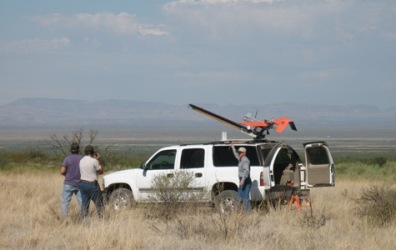
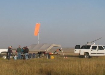
At the Jornada Experimental Range (JER), ongoing research is aimed at determining the utility of UAS for rangeland mapping and monitoring. Over the last 5 years, we have developed a workflow for acquisition, processing, and analysis of fine detail UAS imagery, and for relating remotely sensed information to ground-based measurements. UAS imagery acquired at the JER is currently being used to adapt field sampling approaches to very high resolution imagery, derive parameters for hydrologic models, support repetitive data analysis for a phenology pilot study, assist in evaluation of disturbance experiments, and contribute high resolution information for archeological studies.
 |
 |
In terms of remote sensing, UAS are most similar to piloted aircraft used for acquisition of digital aerial imagery. There are advantages and limitations to using UAS for these purposes. UAS show great promise for remote sensing of rangelands due to the low flying heights, resulting high resolution imagery, and lower image acquisition costs per image compared to piloted aircraft. Current limitations include initial acquisition costs for the UAS, crew training requirements, limited availability of high quality and lightweight sensors, and FAA regulations for operating a UAS in the national airspace.
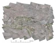
This website contains information about the aspects of our UAS remote sensing project, including operation of our unmanned aircraft in restricted and national airspace, processing of imagery into orthorectified image mosaics, and creation of geospatial products, such as vegetation classifications and terrain models.