

- A National Wind Erosion Research Network (N Webb, J Herrick, C Hugenholtz, T Zobeck , G Okin) - Public concern about wind erosion in the United States is high. This concern has arisen as a consequence of changing and intensifying land use pressures which can lead to increased soil loss and dust emission. However, there is relatively little research to support improved management. While much attention has been given to measuring and modelling wind erosion in US croplands, little information is available on the magnitude and frequency of wind erosion in rangelands and other land cover types. Resolving this knowledge gap is important for soil conservation in the face ongoing land use change, land cover change and climate change. Predictive models supported by high quality, spatially-diverse field measurements are needed to quantify wind erosion across all land cover types so that the impacts can be assessed and management options identified and tested. We present a National Wind Erosion Research Network to support field assessments of wind erosion in all land cover types and the development of an all-lands wind erosion model. We describe the establishment of the network field sites, supported by the US Department of Agriculture’s Long-Term Agroecosystem Research (LTAR) network, Natural Resources Conservation Service (NRCS), Bureau of Land Management (BLM), and Department of Defence (DoD), and outline a standard methods protocol developed to ensure consistency in wind erosion monitoring and assessment across the network. The network will provide opportunities to evaluate controls on the timing and intensity of wind erosion across land use and land cover types in the United States. These data, in support of an all-lands wind erosion model, will provide much needed tools for managing wind erosion and its impacts.
- Multi-scale ecosystem monitoring: an application of scaling data to answer multiple ecological questions (S McCord, E Kachergis, J Karl, D James, D Wilson) - What is the quality of sage-grouse habitat? Is wildfire recovery sufficient to support livestock grazing? Were wildfire restoration and rehabilitation treatments effective?
- Observer trends in the "preponderance of evidence" approach to interpreting indicators of rangeland health (S Perry, S McCord) - Indicators of Rangeland Health (IIRH) can provide a qualitative assessment used to evaluate ecosystem health on rangelands worldwide. The assessment provides an evaluation of three attributes of rangeland health: soil/site stability, hydrologic function, and biotic integrity to identify sites that are departed from reference condition. During the evaluation process, the observer may make a final attribute rating based upon the average of the indicator ratings for each attribute or based upon the preponderance of evidence approach where observer knowledge of the ecosystem and importance of the indicators is used to determining the attribute departure from reference.
- Quantifying accelerated soil erosion through ecological site-based assessments of wind and water erosion (N Webb, J Herrick, M Duniway) - Land use change and intensification have resulted in accelerated rates of soil erosion in many areas of the world’s rangelands. Ecological models of landscape change provide a framework for assessing when erosion controls are modified by land use or management in excess of their natural variability, enabling quantification of accelerated soil erosion. Here we illustrate this approach by evaluating soil erosion rates across five ecological sites in southern New Mexico, USA. We show how patterns and thresholds in erosion responses to vegetation state change and site disturbance manifest across the ecological sites, thus enhancing our capacity to identify practical management solutions.
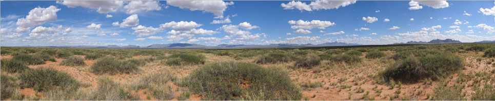
- A national wind erosion monitoring network to support an all-lands wind erosion model (N Webb, J Herrick, C Hugenholtz, G Okin, T Zobeck) - Public concern about wind erosion in the United States is increasing. This concern has arisen as a consequence of changing and intensifying land use pressures, which can lead to increased soil loss and dust emissions and impacts on biogeochemical cycles, agricultural productivity and human health. However, there are few available tools to support improved management. To address the issue a new wind erosion model is being developed to assess net wind erosion across all land uses, including rangelands and croplands. The model development, led by the USDA will provide a tool for land managers and scientists to evaluate the impacts of land management and land use change on rates of wind erosion and dust emission. The model will provide estimates of net horizontal and vertical aeolian sediment fluxes, enabling assessments of management impacts on wind erosion from the plot to regional scales.
- Soil organic carbon dust emission: recent Australian collaborative research (N Webb, A Chappell, C Strong, H Butler, S Marx, J Leys, G McTainsh, R Viscarra-Rossel) - Soil erosion perturbs the carbon cycle by influencing the distribution of soil organic carbon (SOC) across landscapes and soil carbon emissions. Wind erosion selectively removes SOC from vast land areas and transports it quickly downwind. We quantified SOC enrichment of dust sampled across Queensland, Australia and evaluated the mechanisms to inform new models of SOC erosion.
- The role of carbon dust emission as a global source of atmospheric CO2 (N Webb, A Chappell, H Butler, C Strong, G McTainsh, J Leys, R Viscarra Rossel) - Soil erosion plays an important role in the global carbon cycle. Wind erosion contributes to the carbon cycle by selectively removing soil organic carbon (SOC) from vast land areas and transporting it quickly offshore (Fig 1). This augments the net loss of carbon from terrestrial systems. However, the contribution of wind erosion to rates of carbon release and sequestration is poorly understood. Here we quantify SOC losses in dust emissions from Australia and demonstrate the need for wind erosion to be included in carbon accounting systems.
- Sustainable Land Management in Northern Namibia: Opportunities to Integrate Local and Scientific Knowledge Based on an Understanding of Land Use Potential (J Herrick) - This presentation briefly reviews land degradation in the southwest (late 19th - early 20th century) and midwest ("Dust Bowl") US, and how these events relate to challenges we face today globally and particularly in northern Namibia. Degradation there does not appear to be as widespread as in other semi-arid areas of the world, such as the southwestern United States, but it is increasing. It concludes with a discussion of how an understanding of 'land potential' (reflecting both potential productivity and resilience) is needed to guide land management, and a proposal for a 'Land Potential Knowledge System' that integrates local and scientific knowledge. - Northern Namibia faces great challenges in sustaining and increasing agricultural production due to widespread soil and vegetation degradation. Degradation does not appear to be as widespread as in other semi-arid areas of the world, such as the southwestern United States, but it is increasing. Experiences in the United States indicate that irreversible degradation can occur in as little as a few decades. Some lands are more productive, and more vulnerable than others. If these lands can be reliably identified, management can be targeted to increase sustainability. Both scientific and local knowledge are needed to support sustainable land management. Namibia is fortunate to have both excellent universities and other experts with strong scientific knowledge, and farmers who have a tremendous amount of local knowledge. A ‘Land Potential Knowledge System’ (LKPS) is needed to collect, integrate, synthesize and make available knowledge on the land’s potential to produce, and resist degradation. This system would help farmers choose sustainable land management systems, and development organizations to target their work where it will have the greatest impact, and to avoid investments leading to unintended consequences.
- Image Interpreter Tool (II) (S Schrader) - Image interpreter tool features easy, direct integration into ArcGIS 9.3; simple and intuitive interface for users familiar with ArcMap; users can navigate sequentially or jump to any selected location; provides a platform to easily replicate classifications among many observers or trials; user data is saved automatically at each location; fast and can be used on portable storage devices (e.g. USB thumb drive); and customizable to accommodate project objectives.
- Database for Inventory, Monitoring and Assessment (DIMA) (E Courtright) - The Database for Inventory, Monitoring and Assessment (DIMA) is a highly customizable tool for data entry, assessment, monitoring, and interpretation. DIMA is a Microsoft Access database that can easily be used without Access knowledge and is available at no cost. Data can be entered for common, nationally accepted (by NRCS, BLM and others) vegetation and soil monitoring methods, including the methods described in the “Monitoring Manual for Grassland, Shrubland, and Savanna Ecosystems”.
- Multiscale Variability of Soil Aggregate Stability: Implications for Rangeland Hydrology and Erosion (M Duniway, J Herrick, K Spaeth, N Barger, J Van Zee, J Belnap) - Why soil aggregate stability? Soil surface characteristics control capture and retention of water and nutrients. Soil aggregate stability is related to soil erodibility and infiltration capacity, both of which are: highly variable in space and time, and difficult to measure.
- Land Use Planning and Early Warning Systems for Limiting Drought Impacts and Promoting Recovery (J Herrick, J Angerer, B Bestelmeyer, M Duniway, K Havstad, E H-Sannwald, A Laliberte, et al.) - Land use plans (based on land potential) can be used together with early warning systems to help individuals, communities, and nations minimize drought impacts by helping to focus attention on the least resilient areas before the drought begins.
- Long-term Monitoring for East Africa: Rangeland Monitoring Workshop and Field Day (J Herrick, C Riginos) - Project objective is to develop standardized long-term monitoring protocols for East Africa with a foundation in local knowledge that reflect changes in land's capacity to support multiple ecosystem services including livestock production and wildlife conservation...