(The following text and figures are from: Herrick et al., 2010, Frontiers in Ecology and the Environment 8: 403-408.)
Associated press release - New USDA Study Shows Extent of Land Degradation and Recovery on Western Rangelands
An understanding of the extent and severity of land degradation and recovery is necessary to guide land use policy and management, yet currently available assessments are widely known to be inadequate. We describe results of the first statistically-based application of a new approach to national assessments that integrates scientific and local knowledge. Qualitative observations completed at over 10,000 plots in the United States showed that while soil degradation remains an issue, loss of biotic integrity is more widespread. Quantitative soil and vegetation data collected at the same locations support the assessments and serve as a baseline for monitoring the effectiveness of policy and management, including responses to climate change. For example, non-native species currently occur on nearly 50% of non-federal rangelands, and account for at least 50% of plant cover on over 5% of these lands. These results provide information necessary to support strategic decisions by land managers and policy-makers.
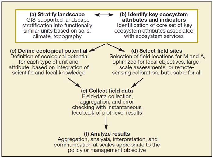
General approach to monitoring and assessment (“M and A”) applied in this study. See text for detailed explanation.
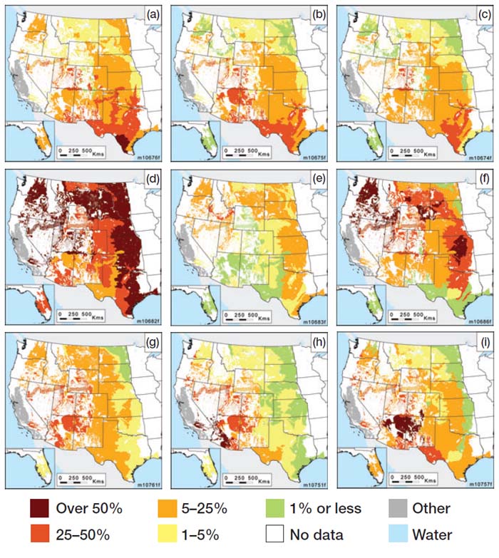
Results of land-degradation assessment relative to reference conditions (a–c) and status of key quantitative indicators (d–i) for non-federal rangelands in the US. Proportion of rangeland where (a) biotic integrity, (b) hydrologic function, and (c) soil and site stability were rated moderately degraded or worse, relative to the reference. (d) Proportion of land where non-native species are present and (e) comprise over 50% of plant cover. (f) Proportion of land where non-native annual Bromus species are present. (g) Bare ground, (h) proportion of soil surface in large (>1m) intercanopy gaps, and (i) proportion of soil surface covered by soil aggregates with low stability in water (field test < 3; Herrick et al. 2005).
Although this example as illustrated in these two figures relied on many dedicated data collectors and therefore had a relatively high cost, the basic approach could be adapted for application by a diverse network of land managers. Recent advances in cellular phone and Global Positioning System technologies provide the opportunity for individuals with limited formal training to collect and transmit data on soil-surface conditions and vegetation composition and structure at specific locations in the course of their daily activities. Geolocated data and photographs facilitate data verification and quality control, whereas the ability to make local knowledge spatially explicit and electronically searchable through annotated photographs opens the door to a new source of metadata for interpretation (FAO 2010). Spatially explicit local knowledge is particularly important for identification of thresholds or tipping points (UNEP 1997; Gillson and Hoffman 2007; Bestelmeyer et al. 2009), because these thresholds often depend on spatially and temporally variable management systems, which are rarely documented. Local knowledge is also critical for determining the relative importance and relevance of different ecological thresholds and for defining thresholds of potential concern, which can be used to strategically adapt management techniques (Biggs and Rogers 2004). Widespread availability of information and communication technologies, an increased understanding of the value of local knowledge, and a willingness to standardize methods across regions to realize the benefits of spatial data integration are key to emerging approaches to assessment and monitoring. Data from programs such as the NRI can be used alone or as future inputs for integrated assessment models, as part of ongoing efforts to develop local, national, and international land-degradation assessment and monitoring systems. Future efforts must continue to combine remote-sensing and field-based approaches to biophysical data collection with increased understanding of socioeconomic and cultural patterns and processes (Reynolds et al. 2007; Verstraete et al. 2009) to focus attention on areas at or near a threshold or tipping point.
References used in this summary:
- Bestelmeyer BT, Tugel AJ, Peacock GL, et al. 2009. State-and-transition models for heterogeneous landscapes: a strategy for development and application. Rangeland Ecology and Management 62: 1–15.
- Biggs HC and Rogers KM. 2004. An adaptive system to link science, monitoring and management in practice. In: du Toit J, Rogers KM, and Biggs HC (Eds). The Kruger experience: ecology and management of savanna heterogeneity. London, UK: Taylor and Francis.
- FAO (Food and Agriculture Organization). 2010. Land degradation assessment in drylands. Rome, Italy: FAO. www.fao.org/nr/lada/. Viewed 10 Jun 2010.
- Gillson LG and Hoffman MT. 2007. Rangeland ecology in a changing world. Science 315: 53–54.
- Reynolds JF, Stafford Smith DM, Lambin EF, et al. 2007. Global desertification: building a science for dryland development. Science 316: 847–851.
- UNEP (UN Environment Programme). 1997. World atlas of desertification, 2nd editionn. London, UK: Edward Arnold.
- Verstraete MM, Scholes RJ, and Stafford Smith M. 2009. Climate and desertification: looking at an old problem through new lenses. Frontiers in Ecology and the Environment 7: 421–428.